Leah Fulton
Treaty Relations of the Salish Sea
Cartography, as an ever-evolving discipline, necessitates ongoing critical engagement with the question, “Who is the map for?” This inquiry is particularly pertinent in addressing the colonial narratives that have historically shaped mapping practices.
.png)
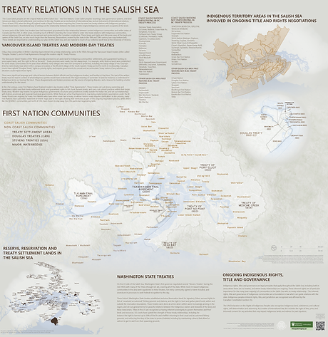
Invited by Associate University Librarian, Reconciliation Ry Morran (also the founding director of the National Centre for Truth and Reconciliation) to contribute to a large, highly visible public installation, we were challenged to go beyond land acknowledgements; to evoke the geography of treaty relations of the lək̓ʷəŋən peoples on whose traditional territory the university stands in broader context of the varied treaty relations of the larger region the university operates in.
This work opens critical dialogue about the limitations of conventional spatial delineations and compels cartographers to rethink approaches to the layers of reclamation, transboundary relationships, and the representation of interconnected socio-ecological relationships. It also highlights how cartographic practices must attend to local understandings of land tenure, sovereignty, and dynamic, emergent relations with the state contribute to the reclamation of land and relationships within the Salish Sea.
Institutional Responsibility
The practice of acknowledging Indigenous territory has become a familiar opening for meetings and events across Canadian universities. It is a vital gesture of respect, a first step in recognizing the enduring presence of Indigenous peoples on lands that have been their homes since time immemorial. Yet, as both the 1996 Royal Commission on Aboriginal Peoples and the 2015 Truth and Reconciliation Commission of Canada (TRC) have made clear, the responsibilities of public institutions, particularly in education, extend far beyond this initial acknowledgement.
Truth and Reconciliation Commission (TRC) Calls to Action
Action 62: Education for reconciliation
The TRC’s Calls to Action, specifically those directed at education, implore us to develop culturally appropriate curricula, and to foster a deeper public understanding of the histories, laws, and relationships that shape our present. The challenge, then, is how to move from a now-routine acknowledgement, which can risk becoming performative, to a more meaningful, reciprocal, and sustained engagement with the complexities of these relationships. How do we, as educators, create tools that disrupt settler complacency and invite genuine inquiry?
Visualizing a Layered and Contested Landscape
Translating the complex legal and historical landscape of Salish Sea treaties into a visual representation presented a series of profound cartographic challenges. There isn’t a list of how to do this, or a guide per say, but we’re being informed by Indigenous Cartographers through best practices in mapping Indigenous territory. Some decisions included those related to orientation, strategic hierarchy, bringing texture, soft boundaries, and simplicity.
.jpeg)

Speaking
L. Fulton, B. Thom. 2025. University of Victoria, Faculty of Law. September 3rd, 2025. Invited Speaker.
L. Fulton, B. Thom. 2025. International Cartographic Conference. Vancouver, British Columbia. August 18-22nd, 2025. Oral Presentation.
L. Fulton, B. Thom. 2025. Canadian Association of Geographers / Canadian Cartographic Association Annual Conference. Ottawa, Ontario. May 20-23rd, 2025. Poster Presentation.